
Updated 17 August 2023: more details on weekend events.
I’ve tried to add our venues, historic buildings, and road-closing information directly to Google Maps.
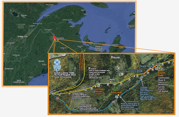
We changed the lineup location for parade and clan marchers. Marchers now line up on Kincardine Road before the junction with Manse Hill Road. Watch for traffic!
Saturday visitors: please use Manse Hill Road to drive to the Events Field and parade parking. This will avoid the parade lineup on Kincardine Road. Watch for children! See map below.
The Parade is Saturday 19th August 2023, 10:30 AM Atlantic Time
This is the civic address to the Event’s Field and parade parking:
260 Kincardine Road, Kincardine, NB E7H 2K5
Here’s a Google Maps link to the Events Field. Just fill in your location for directions (We’re located in Perth Parish in Southern Victoria County):
GPS to Burns Hall:
46.634469, -67.660338
46°38’04.1″N 67°39’37.2″W
Sign up to be in the parade: Join Our Scotch Colony Parade!
Sign up to march with your clan at the head of our parade.
Caution: When driving to/from Upper Kintore to/from Kincardine, avoid the Bon Accord Cross Road. There are reports of flooding and washouts. (Google Maps seems to prefer this route.) Use Kintore Road instead.

Above: Scotch Colony Google Map. Zoom in and scroll around to see the detailed points of interest. The 150th celebration areas are outlined in orange. Navigate to any point using the Google Maps app on your smartphone.
You must be logged in to post a comment.