Scotch Colony Architecture [draft post]

The History, Character, & Architecture of Kincardine, Bon Accord, Upper Kintore & Lower Kintore

by L. Darlene Morton
April 1975 (unpublished manuscript; Published electronically 2023)

[This web version is under construction. Here’s a link to photos of the complete document: images of Darlene Morton’s original typed document including all illustrations, drawings of interior layouts, and original photographs of the buildings]

Acknowledgements

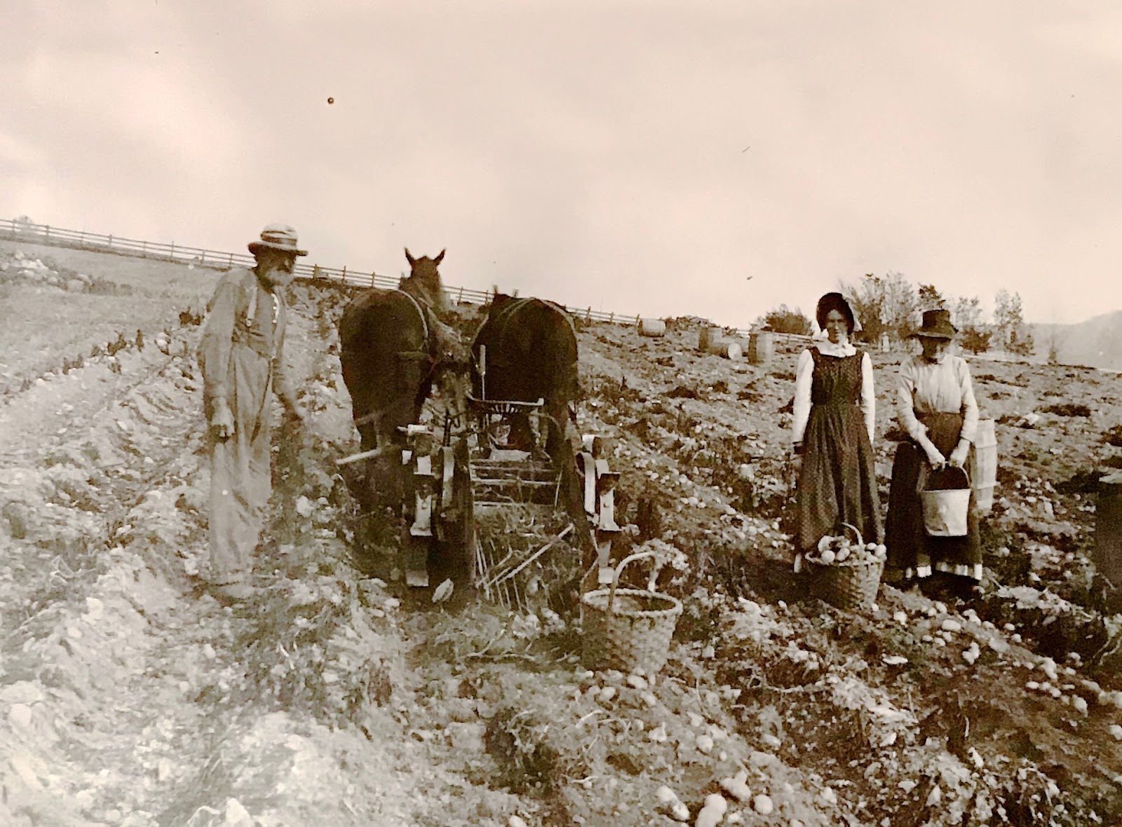
I wish to thank my mother, Kathleen Morton for providing me with most of the information about Kincardine, my father, Lloyd Morton for the transportation, Jim Barclay for the information about Upper and Lower Kintore, and Katherine Warman for that of Bon Accord.

Also I would like to thank all of the people of the Colony who were so helpful, my aunt, Ruby Phillips for the use of her camera, my brother-in-law, Charlie Cameron for taking some of the pictures, the Provincial Archives for developing some, and Vera Guitard for typing the project.

Potato harvests in Kincardine – Andrew Ellis, Mary Chapman, & Annie Ellis.

History of the Scotch Colony

Scotch Colony lot map (see also Crown Land Grant Map Viewer for a slightly different version)

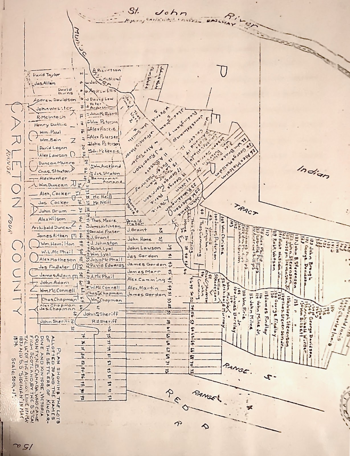
The Free Grants Act of 1872 passed by the New Brunswick government, provided for the settlement of some of the Crown Lands of New Brunswick through the granting of free tracts of land to any individual or groups of immigrants who agreed to the provisions of the Act.

Continue reading

Crown Land Grant Reference Map Viewer

This is the actual Crown Grants Reverence Map viewer embedded here on this page. Click the “agree to the above terms…,” then click “OK.” (map is centred on Upper Kintore?–drag map): 

If this doesn’t work, here’s the web link:

http://geonb.snb.ca/GRP/index.html

The underlying Bureau of Lands and Mines lot-map (cadastral) images of the Colony are a little different than other versions I’ve seen (I’ve seen six or seven versions so far).

When you zoom in on the map, you can see the modern subdivisions. You can change the underlying map to reveal aerial photos (these are different photos than on Google Maps) instead of the old paper maps.

Click on the yellow grant reference points to see the lot number, date of the grant, and the full name of the grantee. The grant number can be cross-referenced with the “Index to New Brunswick Land Grants, 1784 – 1997 (RS686)” at PANB: https://archives.gnb.ca/Search/RS686/Introduction.aspx?culture=en-CA. Click on “Search Page” link to enter the grants database.

Here is a screen shot (of an older version of viewer) showing a zoomed-in view of just the Colony area. All of New Brunswick is included on their map:

This map viewer is superior to what I have been trying to do with our Scotch Colony Google Map, because it shows lot lines and subdivisions. However, one nice thing about Google Maps is that you can navigate to any point using your cell phone/device with the Google Maps app. (After you view the Scotch Colony Google map, you should find it listed in your “Saved”: “Maps.”)

Of course, cell reception is spotty in most of the Colony so it is best to download our Scotch Colony Google Map to your mobile device and add your own points of interest (on top of our points of interest). The mobile device’s GPS capabilities should help you navigate when you’re out of cell range.

Please respect local landowners.

Another interesting online map is the SBN Property Assessment Online https://paol.snb.ca/paol.html?v=1.0.47&lang=en

1874 Cadastral, Lower and Upper Kintore

I copied this map from the Provincial Archives of New Brunswick when they came up to the Gathering of the Scots in 2018. We have seen about 6 different cadastrals that cover this area. Stonehaven Settlement is the area to the south of Lower Kintore–it is now called Kincardine and Bonaccord. Here is the Stonehaven Settlement cadastral.

1874 Cadastral, Stonehaven Road (now Kincardine and Bonaccord)

I copied this map from the Provincial Archives of New Brunswick when they came up to the Gathering of the Scots in 2018. We have seen about 6 different cadastrals that cover this area. I’ve rotated this map to make it easier to read the names.

Here is the Lower Kintore and Upper Kintore cadastral.

Colony cadastral, interactive version

Zoomed view. Click image to go to map.

Scotch Colony area view. Click image to go to map.

This is the same combined map from NB Dept of Lands and Mines I had in an earlier post, but now it’s interactive – overlayed on Google Maps.

Zoom (controls in lower right) and scroll (drag mouse). Remove overlay for a better view of the underlying satellite photo.

It may take a while for the overlay to appear. It’s a big file.

The overlay is misaligned near the edges. Look at the underlying photo for roads, fields, and clearcuts to reorient lot lines.

The original cadastral images were downloaded from the Provincial Archives of New Brunswick. I still don’t know what time period is represented on the maps. Probably after 1880 to 1980.

What’s next?

  • add places mentioned in New Kincardineshire by Duncan A MacPhail
  • add more and more…


Plan of New Kincardineshire 1873 Beckwith Map 110917-1

“Plan of New Kincardineshire containing 25,000 acres / by Charles E. Beckwith, D.L.S. [Deputy Land Surveyor]. – 1873. – 1 sketch : pen and ink. The plan gives the names of the settlers, the number of the lot assigned to each, and the number of acres each received (100 or 200 acres). Rivers, streams, and roads are also noted. MC42-MS21-7 B. R. Stevenson fonds, Charlotte County Archives. ”

Note area on right (south) is labeled New Stonehaven, now called Kincardine and Bon Accord further east. The area on the left is labeled Kintore as it is still called.

Jean found the map at the New Brunswick Archives site.

Jean counts 63 lots in the New Stonehaven area with names on them. Of the 63, probably 10 are unmarried sons who qualified for their own 100 acre lot (the lots on the  north side of Kincardine road are 100 acres.)

Were the names written down as families signed up in the (old) Stonehaven, Scotland, newspaper office?

This map was assembled by Bill Duncan from 8 pieces downloaded from the New Brunswick Archives. http://archives.gnb.ca/Exhibits/PlannedSettlements/ImageList.aspx?culture=en-CA&Link=MC42-MS21-7-1of8%7CP29-15&t=Kincardine&title=Perseverance+&p=11&of=14. There is a piece of the map missing (lot 36 in New Stonehaven) on the original scans. The gap I show may exaggerate the distance.

http://archives.gnb.ca/Exhibits/PlannedSettlements/ImageList.aspx?culture=en-CA&Link=MC42-MS21-7-1of8%7CP29-15&t=Kincardine&title=Perseverance+&p=11&of=14

Plan of New Kincardineshire 1873, C. Beckwith.

I’m experimenting with overlaying this map on Google maps satellite photos: http://williamlduncan.com/GoogleMapOverlayAPIBeckwith1873_122217-1.html  Zoom in on the Google map to see any mismatches between the lines on the map image and the edges of the fields visible on the satellites photo.

“Like” the new Facebook Page about Upper Kintore

Garth Farquhar has created a new Facebook Page and is posting “A collection of stories and pictures of Upper Kintore New Brunswick. Upper Kintore was settled in 1874 by Scottish immigrants who came over on the Sidonian”

Please “Like” his page: https://www.facebook.com/UpperKintore/

Garth has also added many points of interest on our Scotch Colony Google Map that identify places in his stories.

View this map, full screen,  in Google Maps. https://www.google.com/maps/d/viewer?ll=46.68191667674333%2C-67.63556170342184&hl=en&z=11&authuser=0&mid=1FJVCNDbiyv7HmsbPJkIw-L0PAUI

Scotch Colony Lot Map (Cadastral) (after 1884?)

Update 10 July 2018:

Success. I figured out how to overlay this map on Google Maps satellite photos. http://williamlduncan.com/GoogleMapOverlayAPI%20122217-1%201.html

Original post:

I understand colonists didn’t get title to the land until they occupied their assigned lot for some time. This map may represent Scotch Colony lot ownership after 1884. I’m using that date because Margaret Cocker’s (mapped on lot 34) husband, James, died in 1884. There are several other widows on the map and the records we have show their husbands died before 1884.

We have more detective-work to find a more exact date. I’ll post any additional information in a reply. Please reply with comments or questions.


(this is a new version of the video, uploaded in the fall of 2014, with newer and sharper underlying aerial photos.)

The video is a flyover of the map, overlayed on Google Earth’s recent satellite photos and 3D topography (elevation exaggeration was set to 2 so there is some extreme distortion). To make text legible, change your YouTube Settings to 720P  (the little gear symbol that appears after you hit play). Hit pause to make it easier to read the map.

I think seeing the lay of the land and today’s forests and fields really brings the map to life and makes it easier to locate the lots. The map is a little out of alignment but look for the logging clear-cuts and field-edges on the photograph to get a more accurate fix.

Here’s a detail of the same map, showing the Scotch Colony.  Click to enlarge.

1200px wide

2616px wide, massive but great detail.

Continue reading

Early southwestern Victoria county map (after 1874/before 1875?)

The Colony is just small in the lower left. Click on map to see a larger version. I’ve lost the source for this map–possibly New Brunswick Archives. Some tracts are labeled: “Granted 1874” and some others: “To be granted 1875” Continue reading

Old map of Colony lots (Cadastral)

This map belonged to Melvin Barclay when it was photographed in the 1980s(?)- Does anyone know the year the map was made or who drew it? This is a link to a slightly larger version to download.

Continue reading